Yosemite National Park

Edited by:
Massimo Martini
Access
Yosemite National Park, on the western slopes of the central Sierra Nevada, is served by four main roads and five entrances. From the south, California State Route 41 runs from Fresno – home to the nearest commercial airport – through Oakhurst and Fish Camp to the South Entrance, near Mariposa Grove; from there, Wawona Road continues into Yosemite Valley. From the west, State Route 140 starts in Merced, runs up the Merced Valley via Mariposa and El Portal, and reaches the Arch Rock Entrance. From the north-west, State Route 120 comes from the San Joaquin Valley and the San Francisco Bay Area and, via Groveland, reaches the Big Oak Flat Entrance; just before the entrance, the road branches off towards Hetch Hetchy Valley, which has its own access point. From the east, the same State Route 120 – known as Tioga Road – climbs from Lee Vining and US Route 395 to the Tioga Pass Entrance, at 3,031 metres. This section is closed due to snow from approximately November until the end of May or June. The roads on the southern and western slopes are open all year round, but snow chains may be compulsory between October and April. From 2026, no vehicle booking will be required for entry; however, an entry pass will remain compulsory. Public transport is provided by the YARTS network: the service along State Route 140 from Merced operates all year round, with a ticket valid for both YARTS and Amtrak trains, whilst the routes from Fresno, Sonora and Mammoth Lakes are seasonal. A free shuttle service operates in Yosemite Valley.
Introduction
Yosemite National Park covers 3,074 km² on the western slope of the Central Sierra Nevada in California. It was established by the United States Congress on 1 October 1890, but protection of the area dates back to 1864: in that year, the Yosemite Grant, signed by Abraham Lincoln, entrusted Yosemite Valley and Mariposa Grove to the State of California to be preserved and opened for public use. It was the first time the federal government had set aside land for this purpose. The park is managed by the National Park Service and has been a UNESCO World Heritage Site since 1984. The highest point is Mount Lyell at 3,997 metres, and the landscape is almost entirely sculpted from granite: vertical cliffs, domes, U-shaped glacial valleys and waterfalls are its defining features, alongside the giant sequoia forests. Around 93 per cent of the area is protected as wilderness, with no roads or permanent settlements.
Description
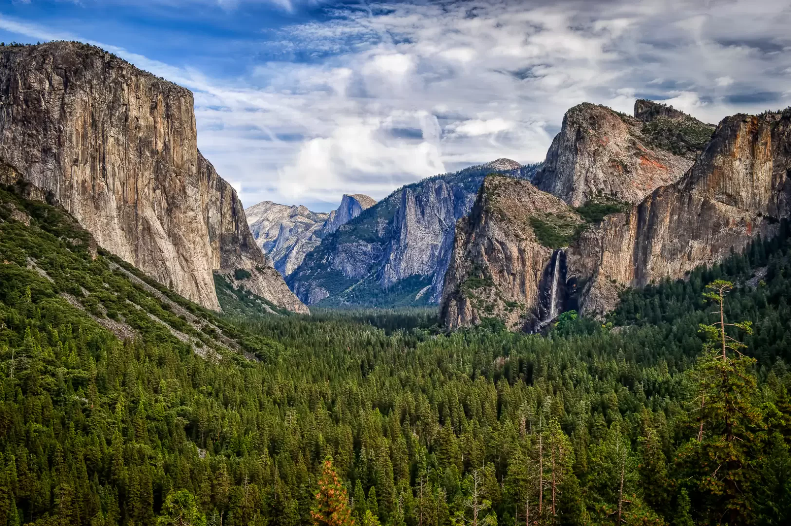
The park stretches across the western slope of the Sierra Nevada, whose ridge forms part of its eastern boundary. To the south-east, it borders the Sierra National Forest; to the north-west, the Stanislaus National Forest. It is also surrounded by three wilderness areas: Ansel Adams to the south-east, Hoover to the north-east and Emigrant to the north. The territory is divided between two catchment areas. The Tuolumne drains the entire northern sector, covering approximately 1,800 km². The Merced rises in the Cathedral Range and the Clark Range and drains around 1,320 km² of the southern sector. Both rivers are designated as Wild and Scenic Rivers and flow westwards through deep canyons between 900 m and 1,200 m deep, down to the Central Valley. The park contains around 3,200 lakes, two reservoirs and over 2,700 km of watercourses. Yosemite Valley, at an altitude of around 1,200 m, accounts for just 1 per cent of the park’s area. The highest peaks are found in theeastern high mountains: Mount Lyell (3,997 m), Mount Dana (3,980 m) and Kuna Peak (3,963 m) all exceed 3,900 m, and the approximate geographical centre of the park coincides with Mount Hoffmann. The waterfalls, fed by snowmelt, reach their maximum flow between April and June. Yosemite Falls has a total drop of 739m across three stages, Ribbon Fall has the highest single drop (491m) and Bridalveil Fall measures 189m.
Almost all the landscape features are carved into the granitic rocks of the Sierra Nevada batholith. These are intrusive bodies formed deep underground in two main phases: between 210 and 150 million years ago and between 120 and 80 million years ago. Around 5 per cent of the territory, mainly along the eastern margin around Mount Dana and Mount Gibbs, consists of metamorphosed volcanic and sedimentary rocks, remnants of the cover that overlain the magma. Over the past 10 million years, the uplift and tilting of the Sierra have increased the gradient of the west-flowing watercourses, which have carved out deep canyons. Erosion has followed the rock’s fracture systems. Where fractures are sparse, the exfoliation of the granite has created domes such as Half Dome and North Dome. At least four glaciations (Sherwin, Tahoe, Tenaya and Tioga) transformed the river valleys into U-shaped valleys. The longest glacier stretched 97 km along the Grand Canyon of the Tuolumne, extending beyond the Hetch Hetchy Valley. Above the floor of Yosemite Valley, El Capitan rises 1,095 metres and Half Dome 1,443 metres. The present-day glaciers, the Lyell and the Maclure, are not remnants of the Pleistocene glaciations: they formed during the most recent Neoglacial phases. Both are retreating; Lyell, the larger of the two, covers approximately 0.65 km².
The park comprises five vegetation zones: chaparral and oak woodlands, lower montane forest, upper montane forest, subalpine zone and alpine zone. The park is home to over 20 per cent of California’s approximately 7,000 plant species, providing habitats for more than 160 rare species; the flora comprises around 1,500 species of flowering plants and 35 tree species. Along the western edge, the mixed forest consists of ponderosa pine (Pinus ponderosa), sugar pine (Pinus lambertiana), incense cedar (Calocedrus decurrens), Colorado white fir (Abies concolor) and Douglas fir (Pseudotsuga menziesii), with stands of California black oak (Quercus kelloggii). Three groves are home to the giant sequoia (Sequoiadendron giganteum), the tree species with the greatest volume: the Mariposa Grove with around 200 specimens, the Tuolumne Grove and the Merced Grove. At higher altitudes, the California spruce (Abies magnifica) and the Jeffrey pine (Pinus jeffreyi) and lodgepole pine (Pinus contorta). Towards the tree line, the whitebark pine (Pinus albicaulis) and the mountain hemlock (Tsuga mertensiana); further up, granite outcrops and alpine meadows extend. The meadows, situated between 900 m and 3,350 m, are largely wetlands.
The park is home to around 90 species of mammals, over 150 species of birds regularly present, 22 species of reptiles, 12 species of amphibians and 6 species of native fish. The black bear (Ursus americanus), the puma (Puma concolor), the bobcat (Lynx rufus), the coyote (Canis latrans) and thespotted owl (Strix occidentalis). At higher altitudes, the fisher (Pekania pennanti) is found; in the Alpine zone, the American pika (Ochotona princeps) and the yellow-bellied marmot (Marmota flaviventris). The Rocky Mountain sheep (Ovis canadensis), in its Sierra Nevada endemic subspecies, is federally endangered and survives in the area as a small reintroduced population around Tioga Pass. Species associated with grasslands include the Lapland owl (Strix nebulosa), the willow flycatcher (Empidonax traillii) and the Yosemite toad (Anaxyrus canorus), a threatened species. The Sierra Nevada yellow-legged frog (Rana sierrae) is also endangered. The brown bear (Ursus arctos), the California condor (Gymnogyps californianus) and Bell’s vireo (Vireo bellii) have disappeared from the park in historical times. In the past, black bears were attracted to rubbish tips and food left in vehicles; today, their management relies on bear-proof containers at campsites and aversive conditioning techniques.
Human presence in the area dates back 10,000–8,000 years. Yosemite Valley, known as Ahwahnee, was inhabited by the Ahwahneechee, who were related to the Miwok of the southern Sierra; the name Yosemite derives from the term the Miwok used to refer to this people. In 1851, during the Mariposa War, the Mariposa Battalion, a militia funded by the State of California, entered the valley to drive out its inhabitants. Their accounts constitute the first documented evidence of European-Americans entering Yosemite Valley. On 30 June 1864, the Yosemite Grant entrusted the valley and Mariposa Grove to the State of California as an area for protection and public use. John Muir and Robert Underwood Johnson led a campaign against sheep grazing on the high-altitude grasslands, which led Congress to establish the national park on 1 October 1890 around the areas already granted to the State. In 1906, the valley and Mariposa Grove also came under federal jurisdiction. The park was garrisoned by the army until 1916, when it was transferred to the National Park Service, which had been established that year. The Raker Act of 1913 authorised the O’Shaughnessy Dam in the Hetch Hetchy Valley to supply water and electricity to San Francisco, despite opposition from Muir and the Sierra Club. In 1969, the National Park Service removed the last indigenous families living in the valley and demolished their village. The California Wilderness Act of 1984 designated the Yosemite Wilderness, which now covers approximately 93 per cent of the park.
The park contains two National Historic Landmarks. The first is the Sierra Club’s LeConte Memorial Lodge, the first public visitor centre in Yosemite Valley; the second is the Ahwahnee Hotel, built in 1926–27. The Wawona Hotel was built in 1879 to accommodate visitors to Mariposa Grove. The Yosemite Museum, founded in 1926, displays collections relating to Native American culture; behind it, the Ahwahnee Indian village has been reconstructed. Camp 4, a campsite in Yosemite Valley linked to the origins of climbing as a sport, is listed on the National Register of Historic Places. The Wawona Tree, a sequoia in Mariposa Grove through which a tunnel was cut in 1881 to allow carriages to pass, stood there until it collapsed in 1969. The black-and-white photographs by Ansel Adams, who lived in the park for many years, helped to cement its image.
The hiking network comprises 1,288 km of trails; the tarmac roads measure 344 km. The park is divided into five sectors: Yosemite Valley; Wawona, Mariposa Grove and Glacier Point; Tuolumne Meadows; Hetch Hetchy; Crane Flat and White Wolf. The Pacific Crest Trail crosses the park’s high mountains. The ascent of Half Dome via the cables – which are typically in place from late May to early October – requires a permit allocated by lottery, with a limit of 300 hikers per day. Any overnight stay outside designated campsites requires a wilderness permit and, in most cases, bear-proof food containers. The rock faces of Yosemite Valley, including El Capitan, and the domes of Tuolumne Meadows are popular climbing areas during the snow-free months. In winter, the Badger Pass Ski Area – California’s oldest alpine ski resort – and the cross-country skiing and snowshoeing trails round off the range of activities on offer. Off-road mountain biking is not permitted.
Information
General information
Type: National Park; IUCN Category II (national park)
Year established: 1890 (Congressional Act of 1 October 1890); previously: Yosemite Grant, 30 June 1864; annexation of Yosemite Valley and Mariposa Grove: 1906
Managing body: National Park Service
Parent organisation: United States federal government (Department of the Interior)
Area: 3,074 km²
Lowest elevation: n/a
Maximum altitude: 3,997 m
Highest point: 3,997 m – Mount Lyell
Region: California
Counties covered: Mariposa – Tuolumne – Madera – Mono
Official website: https://www.nps.gov/yose